
The Kintyre peninsula is one of our favourite places in Scotland. We went there twice in May 2004 and June 2015 and its very name conjures up many unforgettable memories.

Kintyre road sign © 2004 Scotiana
It’s quite possible to visit the Kintyre peninsula in a one-day trip and we did it but, if you ask me, it’s rather frustrating to do so, not being able to linger here and there as you would like to do, arriving at high tide for the crossing to the island of Davaar and, still worse, to be obliged to walk down au pas de course to reach the mythic lighthouse… in fact, we had planned to spend two nights in Kintyre, one at Machrianish in the south west of the peninsula and the other at Crossaig in the north east, not far from Claonaig where we wanted to take the ferry to Arran but, as we had only a few days left in Scotland and still so many places to visit, we decided to cancel our night at Machrianish…
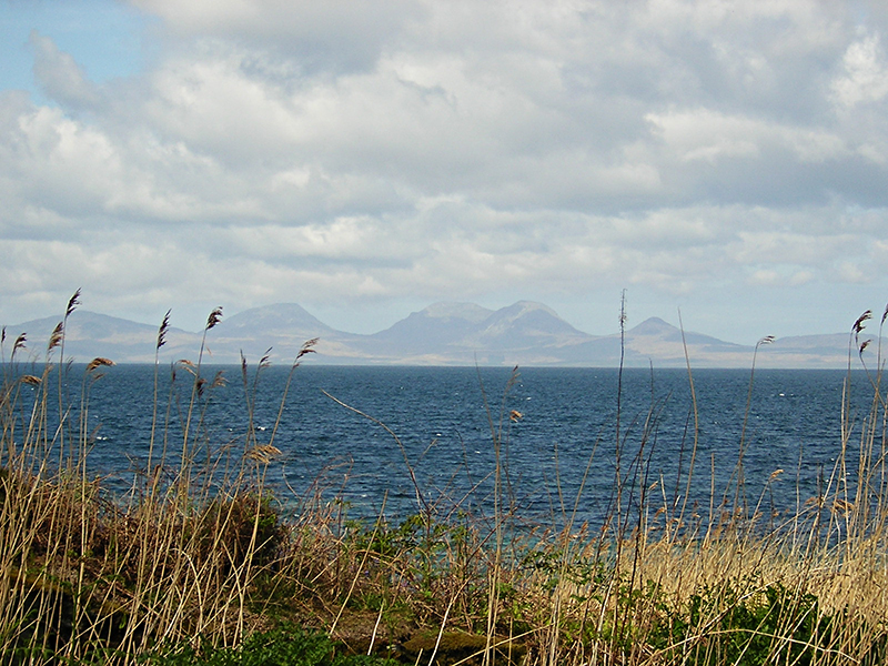
View of the Paps of Jura from the Kintyre road © 2004 Scotiana
The scenic road of Kintyre offers breathtaking views of the Paps of Jura, of Gigha, Arran and other small islands like Davaar island, Sanda and even Ailsa Craig in the distance…

The Kintyre Peninsula – Michelin map modified by Scotiana
The peninsula of Kintyre, nearly an island, stretches about 30 miles from East Loch Tarbert in the north to the Mull of Kintyre in the south.
From here , as you can see on the above map, it’s easy to sail to Islay, Jura, Colonsay and Oronsay, Arran and also to Ireland…

Armeria maritima blooming on the Kintyre shore in May © 2004 Scotiana
We’ve followed the scenic road which makes the tour of the peninsula, stopping very often to take pictures of the lovely seascapes.

Big rocks standing guard on the Kintyre seashore © 2004 Scotiana
Here and there, big rocks look like stone creatures keeping watch over the place…

Views of the Kintyre seashore © 2015 Scotiana
The Kintyre is indeed a lovely place with its blue waters and sandy beaches, its peaceful villages and towns, its ancient vestiges which testify to a rich history…
A 83 southwards…
- Tarbert
- West Tarbert

Kintyre Kennacraig ferry terminal © 2015 Scotiana
- Kennacraig ferry to Islay
- Whitehouse
- Clachan: it is a small village and the site of an old church. It used to be the main church for the North Kintyre area and it is surrounded by an old churchyard sheltering carved stone statues of the Chiefs of the Clan Alasdair.
- Ballochroy, not far from Clachan, a megalithic site with interesting standing stones.
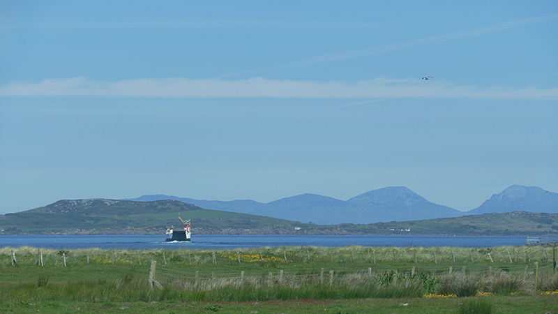
Tayinloan-Gigha ferry West Kintyre © 2015 Scotiana
- Tayinloan : here’s the ferry terminal to Gigha Island
- Killean
- Muasdale
- Glenbarr : a small village on the west coast with, nearby, Glenbarr Abbey, a picturesque 18th-century residence which now serves as a visitor centre for the history of Clan MacAlister.
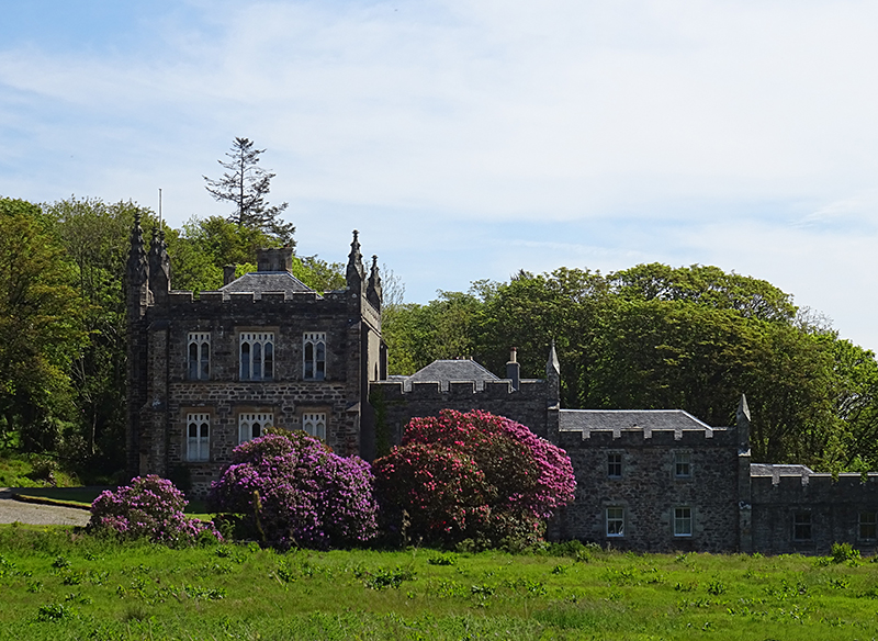
Glenbarr Abbey West Kintyre © 2015 Scotiana
- Bellochantuy
- Kichenzie
- Campbeltown

Views of Campbeltown and its medieval Celtic Cross in Kintyre © 2015 Scotiana
Campbeltown is a turning point…

Kintyre crossroads © 2015 Scotiana
and the driver can choose between three itineraries.
- He can take the B 842 and drive northwards along the eastern coast of the peninsula in the direction of Tarbert.
- He can turn on the B 843 which goes westwards in the direction of Machrihanish
- He can follow the A 83 on a short distance to take the B 842 which goes southwards.
We would have loved very much to go and walk on the beautiful sandy beach of Machrihanish but as we didn’t want to miss our excursion to the Mull of Kintyre nor to arrive too late at our B&B in Crossaig, on the north east of the peninsula, we decided to go southward at once.

Kintyre Southend road © 2004 Scotiana
Thus we took the A 83 and then the B 842 which led us first to Southend and then to the Mull of Kintyre with its famous lighthouse but to reach this mythical point you’ll have to follow a narrow and dangerous single track road for miles, up to a signpost which reads “end of the public road”…

Mull of Kintyre end of public road © 2015 Scotiana8
… but the roads goes on, winding down up to the lighthouse for what seemed to us a long long time… but it’s worth the effort, landscapes are breathtaking, still more for people who are not scared of heights, like me…

Dunaverty Bay and Rock in Kintyre © 2015 Scotiana
- Southend village and Dunaverty Bay, a magnificent sandy beach dominated by a strange rocky outcrop.
- The Dunaverty rock is called “Bloody Rock” because of the massacre which took place there in 1647, at the end of a terrible battle opposing a Scottish Covenanter army led by Major-General David Leslie, and supporting the English Parliamentarians and a royalist army. Though they had surrendered, 300 jacobites, mainly MacDonalds and MacDougalls, were savagely executed.

Dunaverty castle in the 1500s – reconstructed image by Andrew Spratt
- As you can see on Andrew Spratt‘s reconstructed image of the place, it was used as a fortress in the olden times.

Kintyre Southend bay and islands © 2004 Scotiana
- While following the road, we caught sight of the small Sanda and Sheep islands and even made out the recognizable figure of Ailsa Craig in the distance, in spite of the misty weather…

Kintyre Southend Sanda Island and Ailsa Craig © 2015 Scotiana
Who could believe, looking at the above photo, that there is a lighthouse on that small rocky promontory you can see on the right of Sheep Island 😉

Kintyre information board Southend © 2004 Scotiana
- In 2004, we stopped at the foot of a hill where St Columba is supposed to have set foot in Scotland for the first time, in 563, with his twelve followers. There is an old churchyard there, with very interesting graves.
- The Mull of Kintyre at last with its famous lighthouse

Mull of Kintyre lighthouse © 2004 Scotiana
In 2004, as it was too late for us to go down to the lighthouse we stayed up the hill for a long time, admiring the landscape and waiting for the sunset to illuminate it. From there, if the weather is fine, you can make out the Irish coastline. In 2015, in spite of a windy and rainy weather, we decided to follow the narrow winding road leading to the lighthouse which stands on vertiginous cliffs. In her next post, Janice will tell you more about this mythic building and our memorable walk to reach it… quite an adventure!
- Back to Campbeltown
This time again we had to content ourselves with pictures of Davaar Island. It is linked to the mainland by a natural shingle causeway called the Dhorlin. The crossing can been made at low tide in around 40 minutes. We would have loved to discover this island with its lighthouse, its caves and of course the famous Crucifixion painting.

Davaar Island off Campbeltown south Kintyre © 2015 Scotiana
In 1854, a Lighthouse was built on the north of the island by the lighthouse engineers David and Thomas Stevenson. The lighthouse was automated in 1983, and today, Davaar is inhabited by caretakers, sheep, goats and mink.
The Lookout, a square building standing on a small knoll close to the lighthouse, was built during World War Two to house naval crews, whose task it was to stretch anti-submarine nets across the water, protecting Campbeltown. It is now rented out as a holiday home.
Entrance to the cave containing Archibald MacKinnon’s paintingThe island is also known for its seven caves, one of which contains a life size cave painting depicting the crucifixion, painted in 1887 by local artist Archibald MacKinnon after he had a vision in a dream suggesting him to do so. The painting caused uproar in the area as it was seen as a sign from God; it is said that when the townsfolk discovered it was MacKinnon, and not God, he was exiled from the town indefinitely. Restored several times since, including twice by the original artist, the painting was vandalised in July 2006, having a red and black depiction of Che Guevara painted over the original masterpiece. It has since been restored again.
Davaar Island is one of 43 tidal islands that can be walked to from the mainland of Great Britain and one of 17 that can be walked to from the Scottish mainland.
In 2001 the island had a population of 2 as recorded by the census but in 2011 there were no “usual residents” living there. (Wikipedia)
B 842 northwards
- Campbeltown
- Peninver

Saddell ruined abbey in Kintyre Scotland © 2015 Scotiana
- Saddel Abbey, a very old and mysterious place to which I will devote my next post 😉

Three knights on carved stone slabs in Saddell Abbey Kintyre © 2015 Scotiana
- Dippen
- Carradale
- Grogport

Crossaig Lodge B&B in Kintyre © 2015 Scotiana
- Crossaig Lodge ***** : a warm welcome was waiting for us there though we arrived at a late hour. After a good night of sleep in a cosy country house and amidst a lovely and peaceful environment we enjoyed the top of breakfast to begin the day early in the morning. What else could we ask for ? Many thanks to Susan and Angus !
- Claonaig : early in the morning off we sailed to Arran aboard the familiar Caledonian MacBrayne ferry… bye bye Kintyre… ce n’est qu’un au-revoir !

Claonaig-Lochranza ferry © 2015 Scotiana
I can’t help to end my post in music with… guess who 😉
https://youtu.be/Tn5y6bOLizA
Enjoy and don’t forget to include the Mull of Kintyre in your next trip to Scotland.
A bientôt.
Mairiuna
Leave a Reply